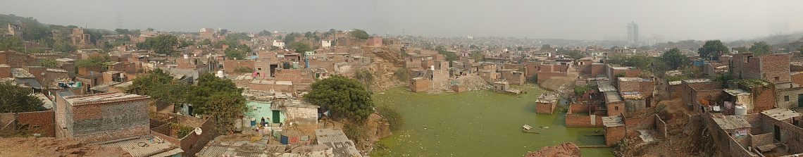
Purani (Old) Khori Gaon
The part of the Aravalli hills where Khori Gaon is located, also called the Southern Ridges, fell under the surrounding villages’ common land. The forest seen in this area was semi-arid with thorny foliage[1]. The gujjars who lived in the nearby villages were pastoralists and used the hills to herd their cattle. When the Britishers captured Delhi in the 1800s, they started acquiring the commons through the Waste Land Act of 1863[2] and forests through the Forest Act of 1865[3]. As the gujjars lost their livelihoods they started subdividing and privatising the common lands. After independence, the Indian government continued the forceful acquiring of common lands, forests, and water bodies. Some of the villagers then started selling their private land parcels to powerful bureaucrats, real estate developers or leased them to mining companies.
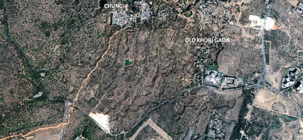
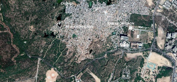
The Southern Ridge was also the Aravalli range’s quartzite table. As a result, this area witnessed heavy quarrying from the 1950s till the 1990s before it was checked by the Supreme Court. A record number of 240 villages in Haryana moved from agriculture to mining[4]. Between 1992 and 2009, multiple court orders were issued, initially for compliance with sustainable mining practices and then for a complete ban on mining in Haryana. Some of the early residents of Khori Gaon are the families of the quarry workers who started settling down here between 1970 to 1990. Fig 1 shows that the early residents settled down on the east side, which is referred to as Purani (Old) Khori Gaon. The google earth image shows the area extent of Old Khori Gaon in 2002.
The quarry workers had migrated from Uttar Pradesh, Bihar, Madhya Pradesh, Jharkhand and West Bengal. Many of these workers were victims of debt bondage at the hands of their quarry contractors and could not go back to their villages. In addition, they also suffered from silicosis and other health ailments due to exposure to dust during mining. After the mines were closed, they found alternate employment as casual labour and daily wage workers in various offices, hotels, malls and gated societies that came up in the vicinity. Most of the residents of Old Khori Gaon have access to municipal water and electricity from the Haryana government. Mostly these residents are the ones in Khori Gaon with identity cards from Haryana.
New Khori Gaon
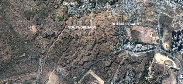
After illegal mining dwindled, the land was soon grabbed by the mafia and sold to urban poor from 2000 onward. The decade of the 2000s also saw several slum demolitions in Delhi. Urban poor from different parts of Delhi, who either could not afford to buy a house in the city or were displaced from other informal settlements and urban development projects, moved here. Villagers from the nearby states had also migrated here for job opportunities. Most of them had sold their land in the villages and moved to the city. Others spent their life’s savings to buy plots and construct their houses. All these residents had purchased their plots from the land mafia active in this area. Fig 2. shows that New Khori Gaon started developing south of Chungi.
For the longest time, the residents were unaware that this was deemed forest land. In many cases, the unsuspecting residents were provided with fake property documents and power of attorney for the land. The Delhi-Haryana border ambiguity has also been exploited by the land mafia, as well as the politicians. Since Chungi, situated in Delhi, had access to municipal services, a plot sold by the mafia claiming its location is in Delhi fetched a much higher amount than the rest of the area.
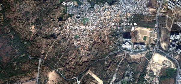
During each election cycle, Delhi, as well as Haryana politicians, have promised services, regularisation and have even provided official documents in return for votes. As a result, a few residents have documents of Delhi and some of Haryana. In some cases, residents have documents from both states. However, a significant number still remain invisible in official registers. Unlike Purani Khori Gaon, the Haryana government did not provide electricity to the residents of new parts of Khori Gaon. Instead, the Delhi government provided electricity and built roads in this area. Fig 3. shows the extent of newly developed area by the end of December 2011.
Even though the residents have access to electricity from the Delhi side in most cases, they do not have papers to prove it since this was supplied through informal channels. They relied on private and state tankers for water. The mafia also exploited the residents by extracting money whenever they built a higher floor or added another room. If there was a gap between purchasing the land and constructing the houses, the mafia often sold the land to other buyers. In some cases, the mafia also grabbed the properties of those who went back to their villages for a few months.
In the high court judgement of 2016, it is mentioned that the Haryana tourist department officials while inspecting the land noticed the basti in 2010. In response, few petitions were filed by the residents before the Punjab and Haryana High Court to request for regularisation or provision of alternate housing. The court cases continued till 2016. During the period between 2010 -2016, instead of a reduction in plotting, there was a significant increase in the selling of plots to the poor. Comparison of Fig. 3 and Fig. 4 shows that between 2011 and 2017, the settlement’s growth has trebled. New residents were offered assurances in exchange for bribes from the forest department, police, and the land mafia (refer to resident testimonies). Hence, the growth of the settlement seems to have involved a nexus of land mafia, bureaucrats from government agencies and police officers.
There was no demarcation or boards claiming that this land was government or forest land till June 2021, which further raises questions about the role of the authorities. Wide publicity to this fact could have prevented thousands of people from being duped into spending their life savings in ‘purchasing’ land here and allowing the unmitigated growth of the settlement. It is only during the demolitions that were carried out recently that the boards have been installed.
[1] Sud, Megha. (2015). Political Ecology of the Ridge: The establishment and contestation of urban forest conservation in Delhi (Vol. 23). Franz Steiner Verlag.
[2] Singh, Subrata. (2013). Common lands made ‘wastelands’: making of the ‘wastelands’ into common lands (29).
[3] Guha, Ramachandra. (1990). An early environmental debate: The making of the 1878 forest act. The Indian Economic & Social History Review, 27(1), 65-84. doi:10.1177/001946469002700103
[4] Pananchikal, Jahnvi. (2018). Why the Aravalli Forest Range is the Most Degraded Zone in India. The Outdoor Journal. Retrieved from https://www.outdoorjournal.com/in/uncategorized/aravalli-forest-range-degraded-zone-india/
[Note: This writeup appears as the chapter titled History of Khori Gaon in the Public Hearing Report – Link]

2 Comments
Comments are closed.